
| Home > Browse Selected Topics | Français | |
This archived Web page remains online for reference, research or recordkeeping purposes. This page will not be altered or updated. Web pages that are archived on the Internet are not subject to the Government of Canada Web Standards. As per the Communications Policy of the Government of Canada, you can request alternate formats of this page on the Contact Us page.
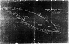
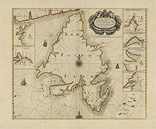
  Investigate!Canada, with the world's longest coastline and largest system of navigable freshwater lakes and rivers, has been at the forefront in providing mariners with useful charts for safe navigation. Without detailed charts, mariners would be forced to rely on their own knowledge and experiences of sailing hazards, making a venture into strange waters a perilous undertaking. Unlike other forms of mapping, nautical charts are considered working documents; they become quickly outdated and require constant revision. Due to this frequent updating, nautical charts provide a wealth of useful information on the nature of physiological changes to the coastlines. As artefacts of the past, they also reflect technological changes in navigation and nautical science, and offer evidential value on boundary locations, the presence of former port facilities, the creation of place names (also known as toponymy) and more. Prior to the late 1700s, nautical chart-making was conducted on an 'ad hoc' basis. The charts were produced by some of Europe's best mapmakers and were generally published as single, discrete items. Library and Archives Canada has an extensive collection of these monographic works. For the most part, they have been catalogued under the name of the creator and are accessible to researchers through the "ARCHIVED - Maps, Plans and Charts" database in ArchiviaNet. With the introduction of systematic hydrographic surveys of coastal waters by British mariners in the late 1700s, chart makers began publishing their work in series. Charts in a series consisted of several sheets that shared common specifications, a uniform format, a collective title and a numbering system. These hydrographic series are retained by Library and Archives Canada in two main collections: one British and one Canadian. British Hydrographic SeriesThe first systematic hydrographic survey conducted in North America was the famous Atlantic Neptune. Surveyed between 1763 and 1774 by Joseph Frederick Wallet Des Barres (also spelled Desbarres and DesBarres), and incorporating work by James Cook, Samuel Holland and William De Brahm, the charts detailed the East Coast from southern Labrador to the Florida panhandle. Published for the first time in 1777, The Atlantic Neptune was reprinted several times until 1781, each reprint incorporating new information. Library and Archives Canada holds some 750 original charts from The Atlantic Neptune. The collection consists of two main components: the first is a complete set of charts acquired from Earl Amherst of Montreal, Sevenoaks, England, in 1926; the second group is a mixture of different states and editions received from various sources. Library and Archives Canada also retains more than 40 coloured coastal views and profiles that Des Barres published separately from the charts to aid mariners in locating harbours. Library and Archives Canada also has the Des Barres papers, consisting of 2.5 metres of original correspondence, memoranda, accounts and land records, which span his entire career as a mapmaker, public servant and landowner in Nova Scotia. The collection also includes 30 rare, original, copper plates from the last edition of The Atlantic Neptune (at one time the copper plates numbered 287, but the majority of these were sold in the nineteenth century as scrap). All the charts have been catalogued in AMICUS under the name of the creator. A modern index map, available in the main reference room of Library and Archives Canada, also helps in locating the areas covered by the Des Barres charts. The views and profiles are catalogued under the "ARCHIVED - Documentary Art" section of ArchiviaNet. Although systematic nautical surveys under the direction of the Hydrographic Services of the British Admiralty began as early as 1801, it took 13 years for Hydrographic Services to enter Canadian waters. In the 70-year period ending in 1884, more than 5,000 Canadian sheets were produced by the British Admiralty. The charts cover the three major coasts and the Great Lakes, and may be located by consulting either index maps or a card catalogue, both of which are available in the main reference room of Library and Archives Canada. In 1884, the Canadian government assumed responsibility for conducting its own hydrographic surveys. However, the British Admiralty continued to print the charts until 1903 and included them in its chart catalogues. Canadian Hydrographic SeriesThe production of the first all-Canadian hydrographic charts -- where the surveying, engraving and printing were done in Canada -- began in 1904. The first chart published was that of Lake Winnipeg and was based on an earlier map prepared by the Geological Survey of Canada. The number of charts in this series has not been determined. It is, however, substantial, since each chart has been revised and reprinted several times. Until the early 1950s, Canada's charts were intended for general navigation. Today, Canada produces four types of charts: merchant marine, small craft, commercial fisheries and national defence. Although early Canadian charts mimicked the style of their British predecessors, Canada gradually developed its own format, one that compiles with international cartographic standards. Index maps, available in the main reference room of Library and Archives Canada, can be used to locate individual charts.
|